
Solutions to Gerrymandering
Most redistricting coverage asks which party gains; we’re asking what happens to the data. For the health systems, foundations, community development organizations, and federal grantees that work by congressional district, mid-decade redraws can make district numbers incomparable to their own history. Second in a three-part series on redistricting. Part one explains what gerrymandering is and how it works. This piece looks at what can be done about it, and part three tracks what changed in 2025 and 2026.
When we first wrote about solutions to gerrymandering in 2017, the question was how to measure it. The Supreme Court was about to hear a Wisconsin case built on a new statistical test, and the expectation — ours included — was that a workable standard would give federal courts a way to police the worst maps.
That is not what happened. Nine years later, the measurement question has been settled by being set aside, and the practical one has changed. It is no longer how do we prove a map is unfair. It is who, if anyone, is still in a position to do anything about it.
The measures we built, and what became of them
Compactness
Compactness was the first attempt at objectivity: a district contorted to capture particular voters tends to look contorted. The Polsby-Popper score compares a district’s area to that of a circle with the same perimeter; a perfect circle scores 1.0, and the more a district sprawls, the closer to zero. It still does real work: several state constitutions require it, which makes it enforceable in those states, whatever federal courts think.
But shape is a proxy. A district can be perfectly tidy and still be drawn to dilute a community’s vote, and it can look bizarre for legitimate reasons — a river, a coastline, a state border. A redrawn map can be more compact than the one it replaced, and compactness would score it as an improvement.
The efficiency gap
The efficiency gap was the more ambitious attempt. Devised by Nicholas Stephanopoulos and Eric McGhee, it sidesteps shape and counts wasted votes: every vote for a losing candidate, plus every vote for a winner beyond the number needed to win. Add up each party’s wasted votes, take the difference, divide by total votes cast. A large gap means one party is converting votes into seats far more efficiently than the other, which is what packing and cracking are for.
It was an elegant measure. We wrote that if the Supreme Court “decides to deny Wisconsin’s appeal, the efficiency gap is likely to be used in many other states to force redistricting.” The Court had already agreed to take the case by the time that ran; what we were predicting was the outcome, and we were confident about it.
We did not get the outcome, and then we lost the forum. In Gill v. Whitford (2018), the Court disposed of the Wisconsin case on standing without reaching whether the efficiency gap was a workable standard. In Rucho v. Common Cause (2019), it closed the door altogether, holding that partisan gerrymandering claims present political questions federal courts cannot decide, no matter how good the evidence is. Chief Justice Roberts did not dispute that the maps before the Court were partisan gerrymanders; he wrote that federal courts had no authority to do anything about it.
That did not make the efficiency gap wrong. It made it homeless. The measure still describes what it always described; there is simply no federal forum in which describing it accomplishes anything.
Where the fight actually went
Rucho closed the federal courthouse. It said nothing about state courthouses, and that is where redistricting litigation has lived ever since.
The clearest example is in our own state. In 2018, a year before Rucho, the Pennsylvania Supreme Court struck down the state’s congressional map under the Pennsylvania Constitution’s Free and Equal Elections Clause. That reasoning never depended on federal doctrine, which is why it survived when the federal route closed. The map was redrawn, and the districts most cited as evidence of gerrymandering in the 2010s, including the 7th, nicknamed “Goofy Kicking Donald”, no longer exist in that form.
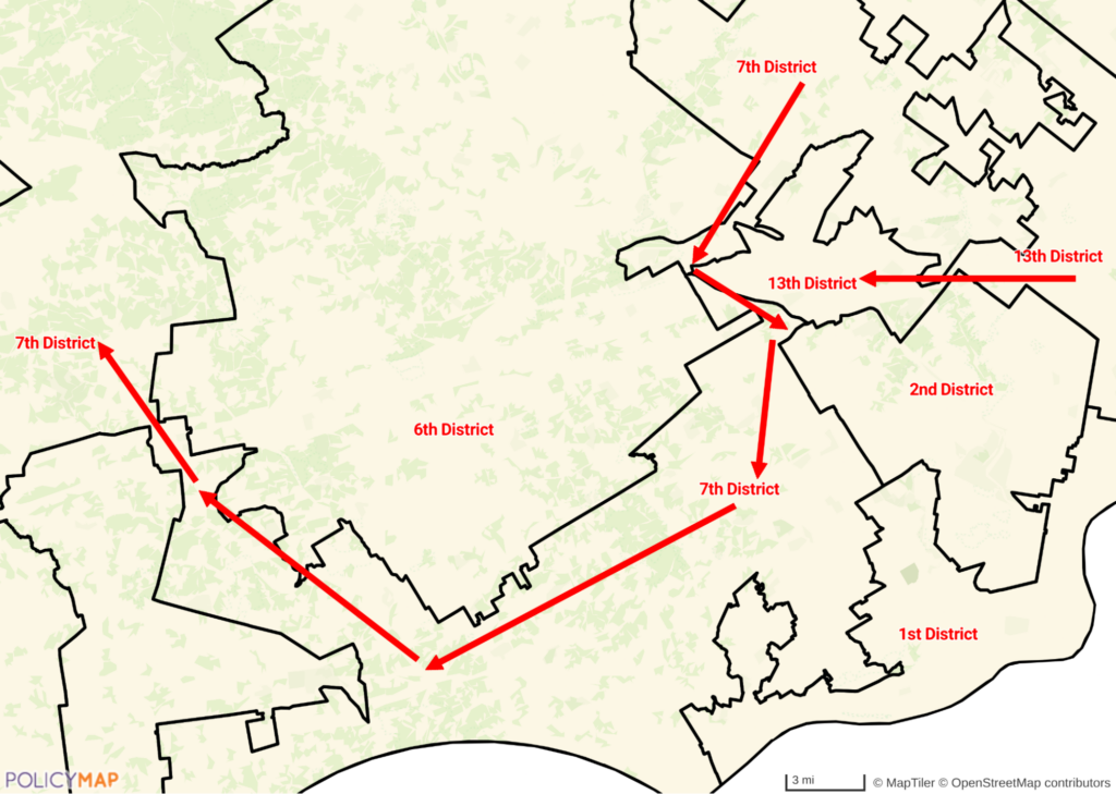
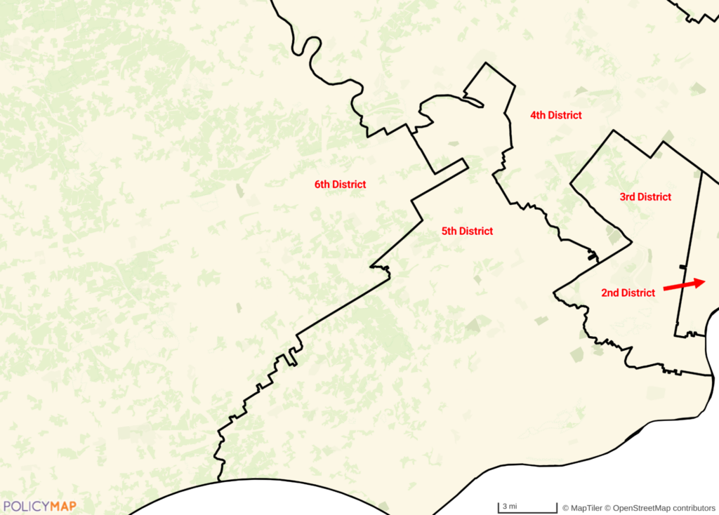
Credit: Map: PolicyMap. Boundaries: U.S. Census Bureau, 115th Congress districts (the 2011 map) and 119th Congress districts (the 2022 plan).
Since the 2021 cycle, partisan-fairness claims have been filed in at least nineteen states, by State Court Report’s count as of July 2024 — a floor rather than a current figure, since it predates the mid-decade round.
The results are mixed. The Wisconsin Supreme Court struck down that state’s legislative maps in 2023, though on contiguity grounds rather than partisan fairness. Courts in Alaska, Kentucky, Maryland, New Mexico, New York and Ohio have held that such claims can be heard under state law, though New Mexico’s and Kentucky’s declined to strike the maps before them. Kansas, Nevada, New Hampshire and North Carolina went the other way, adopting Rucho‘s reasoning as state law; in all but Nevada from the state supreme court, and North Carolina’s had ruled the opposite way little more than a year earlier.
There is no longer a national answer. Whether a map can be challenged, and on what grounds, depends on which state you live in, and increasingly on which way the last state supreme court election went.
The federal floor is gone
Two things changed in the spring of 2026, two days apart, and together they removed most of what remained.
On April 27, the Supreme Court summarily reversed a lower court that had blocked Texas’s mid-decade congressional map after finding it was likely an unconstitutional racial gerrymander. The vote was 6–3, with Justices Sotomayor, Kagan, and Jackson in dissent. The map governs the 2026 election; the merits have not been decided.
On April 29, the Court decided Louisiana v. Callais. By 6–3 it held that Louisiana’s map creating a second majority-Black district was an unconstitutional racial gerrymander — a map the state had drawn to comply with a Section 2 ruling. The decision imposes a substantially harder standard on Section 2 vote-dilution claims: in Justice Kagan’s dissent, a challenger must now show not only dilution but a race-based motive, a burden she described as nearly impossible to meet.
On Ballotpedia’s count from 2024 Census estimates, 148 House districts are majority-minority in the broad sense that minority residents together exceed half the total population. Section 2 runs on a narrower test (a single minority group holding that majority), so the districts it actually required are a subset of those. That machinery is now, for practical purposes, out of service.
Shelby County v. Holder (2013) struck down the formula determining which states had to clear map changes with the federal government first, leaving that requirement with nothing to apply to. Taken together with Rucho, equal population is now essentially the only federal constraint on congressional districting with force behind it. Districts must hold roughly the same number of people; almost everything else is state law.
What is still on the table
Independent redistricting commissions
Independent commissions remain the most-discussed structural fix, and the field has grown since 2017. By the Congressional Research Service’s count, commissions rather than legislatures had primary responsibility for congressional lines in 11 of the 44 states apportioned multiple U.S. House seats after the 2020 census. Most of the eleven are designed to keep elected officials off the commission: Arizona, California, Colorado, Michigan and Washington among them; New Jersey’s is a politician commission, and Virginia’s splits the two evenly. Colorado and Michigan adopted theirs by ballot measure in 2018, after our original post ran; Virginia’s and New York’s also postdate 2010.
Two cautions. “Independent” covers a wide range: Loyola Law School’s redistricting project classifies Ohio’s as a backup commission. Here, a body made up largely of elected officials that draws the lines when the legislature does not. It approved the state’s new congressional map in October 2025, and that map is locked in until 2032.
And commissions are not permanent. They are creatures of state constitutions and statutes, which can be amended, and the last two years’ hardest fights were about exactly that. Virginia’s legislature put an amendment to voters in April 2026 to take congressional map-drawing back from its commission for the rest of the decade; it passed on April 21, and the Virginia Supreme Court struck it down on May 8 because it had not been passed in two properly separated legislative sessions — voiding, before it ever took effect, a new map the legislature had already enacted in anticipation. Utah went the other way: after the legislature effectively neutered the commission voters created in 2018, a state court voided that repeal in August 2025 and restored the commission’s binding standards, then adopted a challenger’s map that November; a later repeal initiative failed to reach the ballot, and the legislature has since tried to move the case into a court of its own making. Commissions survive when someone litigates for them, and in Utah the litigating is not finished.
State voting rights acts
State voting rights acts are the most direct answer to Callais, because they do not depend on the federal statute at all. Eleven states now have a full one. California’s dates to 2002; the rest (Washington, Oregon, Virginia, New York, Connecticut, Minnesota, Colorado, Maryland, Delaware and New Jersey) arrived between 2018 and 2026, three in 2026 alone alongside two expansions of existing acts, in the months surrounding Callais. Illinois has a narrower statute, the Illinois Voting Rights Act of 2011, which governs how its legislative districts are drawn rather than creating a general right of action.
A state VRA protects against vote dilution within that state whatever happens to Section 2 federally. It can do nothing about maps in states without one, which is still most of them; and every one of those eleven acts was enacted under unified Democratic control of the governorship and both legislative chambers, which tells you something about how durable the patchwork is likely to be.
It is also already being tested. On May 8, 2026, the Public Interest Legal Foundation sued Illinois on behalf of former state representative Jeanne Ives, arguing that its 2011 act violates the Fifteenth Amendment and the federal Voting Rights Act by mandating race-conscious districts. Ives v. Pritzker, in the Central District of Illinois, is among the first challenges to a state voting rights act since Callais. It aims at the narrower Illinois statute rather than one of the eleven, but the theory behind it is not narrow. If a state VRA can be struck down for doing what it was written to do, the patchwork is thinner than the count suggests.
State constitutional provisions
State constitutional provisions are the other durable route: free and equal elections clauses, anti-gerrymandering language of the kind Florida voters added for congressional districts in Amendment 6 in 2010, county- and municipality-splitting rules. They are what Pennsylvania used, and only as strong as the state court willing to enforce them.
Ranked choice voting and proportional representation
Changing the voting system is the most fundamental proposal and the least likely in the near term. Proportional representation would make district lines largely beside the point by allocating seats in proportion to statewide vote share, but it would require Congress to repeal the 1967 law mandating single-member districts. Ranked-choice voting does not eliminate gerrymandering, though it changes the incentives around it, and it has moved in both directions since 2017. Maine uses it in primaries and in federal general elections, but not in general elections for governor and the legislature, after a 2017 advisory opinion from its supreme court found that use would conflict with the state constitution. Alaska adopted it by ballot measure in 2020; a 2024 repeal failed there by 743 votes out of more than 321,000, about a quarter of a percentage point. A second repeal, Ballot Measure 2, goes to voters on November 3, 2026, and would also bring back party primaries in place of the top-four system. Ranked choice voting is not a settled question in either state that uses it.
So what is left
Less than there was, and what remains is unevenly distributed. For most of the last sixty years, a person challenging a map they believed was drawn to dilute their vote had somewhere federal to go. That is no longer generally true, and the patchwork that replaced it is worth following state by state, which is why we maintain a tracker of where the maps and the litigation stand rather than a snapshot that will be out of date within weeks.
It is also worth saying what this does not change. The courts have narrowed what counts as a remediable harm. They have not narrowed what is observable. When a district is redrawn and a community that voted together for three decades is divided across four districts, that is still measurable, still mappable, and still true — whether or not a federal judge is now permitted to do anything about it. Evidence and remedy are different things, and only one of them has been taken off the table.
One thing has not changed either, and it is the reason any of this matters: voters should choose their representatives, rather than representatives choosing their voters.
Request More Information
The courts have narrowed what counts as a remediable harm, but not what can be observed. When a community is divided across districts, that division is still measurable and mappable. If your organization needs to see how congressional boundaries line up with the people you serve, fill in the form below. Our sales team will be in touch shortly.