
Data and Good Government
Governments today are being asked to do more with less.

But even as budgets are stretched thin, new tools in data and mapping have made it possible for governments to accomplish more by making better decisions, targeting efforts where they’re needed most.
Many governments have already embraced the power of data and mapping, and tools are available to help them make the most of their efforts. For governments that already have robust data and GIS operations, user-friendly data and mapping tools allow experts to focus on the advanced work they’re capable of doing by empowering non-GIS experts to answer questions on their own.
WHITE PAPER
Sharing Insights, Saving Time: New Data Tools for Government
Easily accessible data and mapping tools allow local, state, and federal governments to:
- Improve coordination between departments
- Identify and address threats to public benefits
- Increase transparency
- Respond to new opportunities by finding capacities for growth
- Expedite grant applications
Learn how leading government agencies are using data on maps for better outcomes.

WEBINAR
Of the People, for the People: Using Data Tools for Good Government
Check out a recent Mapchats webinar and hear from leaders working with local, state and federal governments about how they use data for more efficient and effective government services. We’ll discuss property hubs, non-profits helping building government capacity, data-driven priority and strategy development, and methods for testing and analyzing new ideas in housing and community development. We spoke with Raquel Favela from NDC (and formerly the City of Dallas), Bryce Maretzki from the Pennsylvania Housing Finance Agency, and Steve Barlow from NPI Memphis as they discuss the role of data in their innovative solutions.
Case Study Videos
Watch short case studies on how to use data and maps to solve problems in your community.
Contact Us
Interested in to learning more about PolicyMap, exploring our data warehouse, scheduling a personalized demonstration, or getting a quote?
Share a bit about yourself and your work, and we’ll be in touch in short order.
Data for Governments
PolicyMap contains a wide variety of data to help government departments understand their population.


Customer Stories
PolicyMap subscribers are using data to make their governments run smarter.

The City of Philadelphia uses PolicyMap to quickly and effectively comply with grant requirements, produce strategic plans, and upload local data to overlay with PolicyMap’s indicators.

Connecticut Housing Finance Authority (CHFA)
To illustrate their investments across the state of Connecticut and communicate their work to state legislators, CHFA partnered with PolicyMap to create their Impact Map.
The City of Hartford uses PolicyMap to produce detailed demographic profiles of the North Hartford Promise Zone.
Blog Posts On Data For Government & Policy
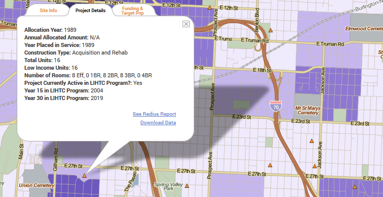
Using Data to Guide Low Income Housing Tax Credit (LIHTC) Preservation Efforts
Use PolicyMap to aid in affordable housing preservation efforts by identifying where existing Low Income Housing Tax Credit (LIHTC) properties may be at risk of losing affordability.
How Opportunity Zones Can Expand Access to Fresh Food in America’s Food Deserts
Opportunity Zones can help grocery stores move into underserved communities. Limited Supermarket Access data can help find those communities.

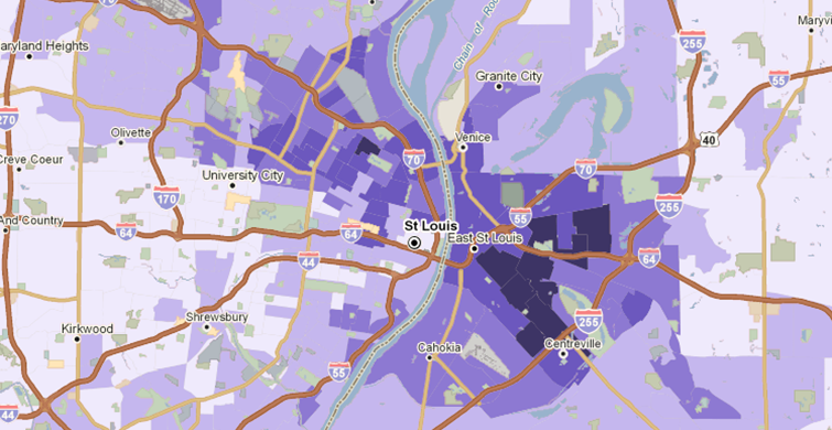
Internet Access Disparities Highlighted in All-New Maps from PolicyMap
According to recent Census data, some city neighborhoods are severely lacking in internet access. See how the digital divide affects your city.