Competitive & Law Enforcement Intel, World News Mapping
I stumbled across two good mapping resources last night. The first is actually a new service available through Google Earth. If you look at the “Layers” now available in Google Earth (in the lower left hand panel) and you check the “Gallery” box, you will discover that there is a new layer there: “Google News”. Check that box and then go wherever you want to go. If Google News has picked up a story from that location, you will see a newspaper icon that you can click on to open up the summary of the story. For more information on this service, take a look at the Google Lat Long Blog.
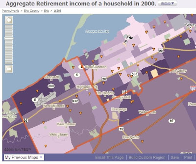
The second mapping resource is a service called PolicyMap. It only covers the US but does a very good job of layering multiple data sets on the NavTeq mapping API. The service breaks down the data in just about any way you might want to see it: By census tract, by zip code, by Congressional District, etc. It provides good leads for business and CI professionals and Law Enforcement Intel types looking at strategic issues. For example, if I wanted to focus a marketing campaign on the retiree communities in Erie, I might want to use the map below that shows aggregated retiree income by census tract in Erie (darker colors mean more retiree income). Its just a screenshot of part of the data, though; if you want the full map, you will have to go to PolicyMap.com as the service provides no embed feature.
Click here to read this article which appeared on Sources and Methods on Thursday May 22, 2008.
