
Reinvestment Fund 2023 Limited Supermarket Access (LSA) Analysis
< Back to list of datasets
Access means different things in different places. In densely-populated urban areas, supermarkets tend to be located more closely together, and a neighborhood may have relatively limited access if its nearest store is a mile or two away. In rural areas, many if not most communities are miles from the nearest supermarket. To account for this variation, Reinvestment Fund assigns every census block group in the nation to one of eleven classes based on that block group’s population density and, for densely populated block groups, car ownership.
Within each class, Reinvestment Fund calculates the typical distance traveled to the nearest supermarket by residents of well-served block groups, i.e., block groups with a median household income at or above 120 percent of area median income (AMI). This reference distance is used under the assumption that in a functioning free market, there will generally exist an adequate complement of amenities like supermarkets in areas where incomes are above average. The population density and car ownership classes, their minimum and maximum population densities, their minimum and maximum percent of households without motor vehicles, and their reference distances are presented in Table 1 below.
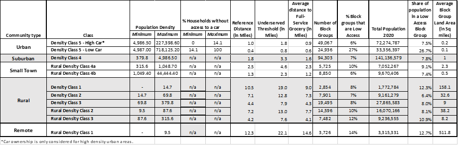
Each block group is then assigned a Low Access Score, which represents the percentage by which that block group’s distance to the nearest supermarket would have to be reduced to equal the typical distance for well-served block groups in that class. Block groups with access scores greater than or equal to 45 are considered limited-access. In those limited-access areas, residents must travel almost twice as far to a supermarket as residents in well-served block groups with similar population density and car ownership. Finally, contiguous limited-access block groups with a collective population of at least 5,000 people are combined to form LSA Areas—areas with both limited access to supermarkets and potentially enough market demand to support new or expanded supermarket operations.
LSA Designation
Limited Supermarket Areas (LSA Areas) are block groups that when combined have at least 5,000 residents who need to travel almost twice as far for a full-service supermarket relative to residents in block groups with similar population density, and above average incomes. LSA areas are places that may be well suited to traditional brick and mortar food retail.
Limited-Access/Low-Population Areas are single block groups with between 1,000 and 5,000 residents who need to travel almost twice as far as residents living in block groups with similar population density and above average incomes. Limited-Access/Low Population Areas have fewer residents than LSA areas and tend to be located in denser parts of the country. Food access interventions in these areas would need to be tailored to the local market and cultural context, but could potentially support expanded food retail opportunities, smaller format stores, or other approaches to augment the local food system.
Limited-Access/Low-Density Areas are block groups with at least 1,000 residents who need to travel almost twice as far as residents living in block groups with similar population density and above average incomes, and that are in the most remote parts of the country. Given the low population and population density of these places, innovative interventions like mobile markets or alternative ownership models may be more financially viable than traditional large format, full-service markets.
Low Access Score
The percent by which a block group’s distance to the nearest supermarket must be reduced to equal the reference distance for that block group’s population density and car ownership class. Low Access Scores indicate the degree to which residents are underserved by supermarkets. Residents of a block group with a higher Low Access Score must travel longer distances to access a supermarket than residents of block groups with lower Low Access Scores. Low Access Scores on PolicyMap range from 0 to 100; block groups with a Low Access Score of 0 have a distance to the nearest supermarket that is less than or equal their population density and car ownership class’s reference distance.
Population Density and Car Ownership Class
The class to which a block group is assigned based on its population density and its percent of households with no motor vehicle. Population density is calculated as people per square mile of populated land area. Water area and land area with no population is excluded. Population data is from the 2010 and 2020 Decennial Census or the American Community Survey 5-Year Estimates (2011-2015). Land area is from the U.S. Census Bureau’s 2020 TIGER/Line Shapefiles. Percent of households with no motor vehicle for all years 2010 through 2020 is from the American Community Survey 5-Year Estimates.
| Categories | Food, Nutrition & Agriculture |
|---|---|
| Detail | Reinvestment Fund Limited Supermarket Access (LSA) Analysis |
| Download Available | Yes |
| Public Edition or Subscriber-only | Public Edition |
| Source | Reinvestment Fund |
| Years Available | 2013, 2017, 2022 |
Description:
Reinvestment Fund’s Limited Supermarket Access (LSA) analysis is a tool to identify areas across the 50 United States and the District of Columbia that have both inadequate and inequitable access to healthy food and sufficient market demand for new or expanded food retail operations. Using the LSA data on PolicyMap, a diverse range of clients—including policymakers, government agencies, lending institutions, community organizations, and researchers—can investigate LSA Areas within their geographies of interest and craft strategies based on the conditions specific to those communities.
Identifying LSA Areas
The LSA analysis measures access to healthy food by identifying areas that are well-served by supermarkets and those that have relatively limited access to supermarkets. Reinvestment Fund uses supermarkets (grocery stores with at least $2 million in annual sales) as a proxy for healthy food access because a review of the relevant research shows that supermarkets, compared to smaller stores (e.g., corner stores), most consistently offer the greatest variety of healthy foods at the lowest prices. Supermarket location data comes from the 2022 Nielsen TDLinx database. Supermarkets include the following store types from that database: supermarkets, supercenters, limited assortment stores, and natural food stores. Superettes and dollar stores are excluded because they are less likely to offer a wide range of healthy foods. Wholesale clubs are excluded because they require a paid membership. Military commissaries are excluded because they are not open to the public. Other data sources include the 2010 and 2020 Decennial Census and the American Community Survey for population, residential land area, households, household incomes, and car ownership rates.Access means different things in different places. In densely-populated urban areas, supermarkets tend to be located more closely together, and a neighborhood may have relatively limited access if its nearest store is a mile or two away. In rural areas, many if not most communities are miles from the nearest supermarket. To account for this variation, Reinvestment Fund assigns every census block group in the nation to one of eleven classes based on that block group’s population density and, for densely populated block groups, car ownership.
Within each class, Reinvestment Fund calculates the typical distance traveled to the nearest supermarket by residents of well-served block groups, i.e., block groups with a median household income at or above 120 percent of area median income (AMI). This reference distance is used under the assumption that in a functioning free market, there will generally exist an adequate complement of amenities like supermarkets in areas where incomes are above average. The population density and car ownership classes, their minimum and maximum population densities, their minimum and maximum percent of households without motor vehicles, and their reference distances are presented in Table 1 below.
Each block group is then assigned a Low Access Score, which represents the percentage by which that block group’s distance to the nearest supermarket would have to be reduced to equal the typical distance for well-served block groups in that class. Block groups with access scores greater than or equal to 45 are considered limited-access. In those limited-access areas, residents must travel almost twice as far to a supermarket as residents in well-served block groups with similar population density and car ownership. Finally, contiguous limited-access block groups with a collective population of at least 5,000 people are combined to form LSA Areas—areas with both limited access to supermarkets and potentially enough market demand to support new or expanded supermarket operations.
Details for Block Group-Level Indicators
LSA Designation
Limited Supermarket Areas (LSA Areas) are block groups that when combined have at least 5,000 residents who need to travel almost twice as far for a full-service supermarket relative to residents in block groups with similar population density, and above average incomes. LSA areas are places that may be well suited to traditional brick and mortar food retail.
Limited-Access/Low-Population Areas are single block groups with between 1,000 and 5,000 residents who need to travel almost twice as far as residents living in block groups with similar population density and above average incomes. Limited-Access/Low Population Areas have fewer residents than LSA areas and tend to be located in denser parts of the country. Food access interventions in these areas would need to be tailored to the local market and cultural context, but could potentially support expanded food retail opportunities, smaller format stores, or other approaches to augment the local food system.
Limited-Access/Low-Density Areas are block groups with at least 1,000 residents who need to travel almost twice as far as residents living in block groups with similar population density and above average incomes, and that are in the most remote parts of the country. Given the low population and population density of these places, innovative interventions like mobile markets or alternative ownership models may be more financially viable than traditional large format, full-service markets.
Low Access Score
The percent by which a block group’s distance to the nearest supermarket must be reduced to equal the reference distance for that block group’s population density and car ownership class. Low Access Scores indicate the degree to which residents are underserved by supermarkets. Residents of a block group with a higher Low Access Score must travel longer distances to access a supermarket than residents of block groups with lower Low Access Scores. Low Access Scores on PolicyMap range from 0 to 100; block groups with a Low Access Score of 0 have a distance to the nearest supermarket that is less than or equal their population density and car ownership class’s reference distance.
Population Density and Car Ownership Class
The class to which a block group is assigned based on its population density and its percent of households with no motor vehicle. Population density is calculated as people per square mile of populated land area. Water area and land area with no population is excluded. Population data is from the 2010 and 2020 Decennial Census or the American Community Survey 5-Year Estimates (2011-2015). Land area is from the U.S. Census Bureau’s 2020 TIGER/Line Shapefiles. Percent of households with no motor vehicle for all years 2010 through 2020 is from the American Community Survey 5-Year Estimates.