PolicyMap: easy GIS data maps

 It seems like I’ve either seen or written about PolicyMap before, but I was reminded of it by the always outstanding Librarians Internet Index blog.
PolicyMap is produced by The Reinvestment Fund (TRF), a national leader in the financing of neighborhood revitalization.
A free (registration required) account allows the user access to most of the 4000 datasets, and the ability to save maps.
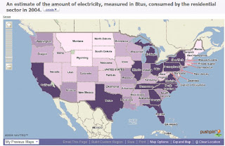
Here’s a screenshot of a very basic map showing the amount of electricity consumed by residential users in 2004 (the last year data is available). You can zoom in for more detailed views, but in this instance the data is compiled at the state level.
A map legend is included, and the user can even determine the number of ranges to color the data in.
Also see the National Atlas, another site that allows the user to generate custom maps with a number of “layers” of data.
Click here to read this article by Jim Dornberg on EdTech Update on Thursday June 5th, 2008.